De Doorns
The colourful valley
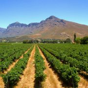
De Doorns is situated in the heart of the Hex River Valley and the centre of a thriving grape growing region, with over 200 table grape farms. 9% of residence live in De Doorns. Breede Valley Municipality has the challenging task of communicating to this diverse group of people. Unlike commercial companies, the municipality’s target market is all the people of the Breede Valley.
Hex River Valley Information
The Hex River Valley is the gateway between the Western Cape’s winelands region, the coast beyond to the south and the plains of the Great Karoo to the north. In fact it is more than simply a gateway as it is the most direct route through the Western Cape Fold Mountains to the north of the country and acts as a logistical funnel for any traffic along this route. The strategic significance of the route has been recognized since the very earliest days of the region’s settlement and has had a strong influence on the development of the valley and adjacent regions to the north.
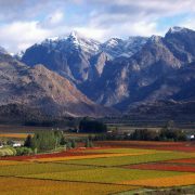
The valley runs from South West to North East. It is 25km long and relatively narrow, measuring only 4km wide at its widest point. The valley is surrounded by the towering peaks of the Hex River Mountains to the North and the Kwadouw Mountain Range to the south which account for the region’s magnificent and rugged scenery. The highest peak in the Hex River Mountain Range is Matroosberg and at 2230 meters it is one of the highest peaks in the Western Cape. It is situated to the North at the eastern end of the valley and the name translates as “Sailor Mountain” it has a very distinctive rock formation on the skyline that resembles a small boat with a sailor standing at the stern.
The valley is both a geological and floral transition zone. The geology of the south west of the valley is part of the Western Cape’s Fold Mountain complex consisting of Table Mountain sandstone. To the north east of the valley this gives way to Bokkeveld Shale and the butte formations typical of the Karoo. The floral transition is from Mediterranean climate fynbos to the Succulent Karoo flora and follows the same geographic transition as the geological one.
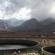
These massive mountain ranges create a vast catchment area for the valley enabling growers to produce premium table grapes. Inhabitants of the valley receive water from mountain streams that have their sources deep in the mountains where during winter the run-off from snow-capped mountain tops seeps gradually down the slopes and into the pristine mountain streams. The runoff also replenishes the water table in the region’s strong aquifers which allows for additional water extraction through boreholes. This water contains minerals and organic material which help create the ideal medium for fruit production.
The vast mountainous area is pristine indigenous Fynbos habitat and supports the full range of indigenous flora and fauna. Sightings of klipspringers, porcupines, baboons, mongooses, rock hyraxes and hares are quite commonplace. Although they are more elusive, the area also supports Cape Jackals, Bat-eared foxes as well as the magnificent Cape Mountain Leopard. The mountains also support an abundant variety of birdlife including large raptors such as black eagles, often seen hunting high above the mountain cliffs.
These ranges also contain reminders of the earliest human inhabitants of the valley. Rock art painted on the cliffs and caves of the mountains has been found to be 7 000 years old and attests to habitation of the area by the /Xam San, the Southern branch of the San tribe of hunter-gatherers. These were the Western Cape’s original inhabitants and the DNA of the San people has proved them to be the closest living relatives to early man. There is evidence that these prehistoric tribes also used the valley as a seasonal migration route, following the herds of antelope into the Karoo during the winter and returning to the permanent rivers in the Western Cape valleys during the summer. Today the spirit of the San is still remembered as locals call the cold wind that blows through the Hex River gorge “die boesmantjie” which translates as the San hunter.
The southern entrance to the valley at Sandhills is through the very narrow gorge formed by the Hex River on its course to the south west. This part of the route is as spectacular as it is strategic as the main national highway, prime national railroad route and a permanent river all negotiate the gorge entrance which is only 270m wide at this point. The strategic value of this route was recognized during the Boer War as this was the site of a tollhouse constructed to control and monitor the traffic along this route. For some months during the war there was also a British garrison posted at the tollhouse. There was clearly reason for concern as in one instance Boer commando’s did in fact travel as far south a mere 40 km north of De Doorns.
The area was also influenced by another war as during the Second World War Italian prisoners of war were sent to South Africa. Farmers had the opportunity to apply to have a group of prisoners assigned to them to live and work on the farms in the district. Several Prisoners of War were placed on farms in Sandhills and elsewhere in the valley for the duration of the Second World War.
It is in the Sandhills area that the original name for the valley, the Ex (X) River, was coined. One explanation is that the confluence of 3 rivers in the area formed an X shape and the other was that as the road was forced to repeatedly cross the river through the gorge, creating numerous X shaped crossings in the process. The name was later changed to Hex River and there is a sad and romantic legend attached to this name which will be examined later. The name Sandhills is a misnomer and is most likely an English corruption of the Dutch name Zanddrift which means sandy river ford.
The northern entrance to the valley by road is down the rapid descent of the Hex River Pass and rewards the traveller with the first spectacular views of soaring mountains and green cultivated landscapes after travelling through the arid Karoo. The entrance by train is also remarkable but more specifically from an engineering perspective. The Hexton Railway Route through the mountains from Kleinstraat Station in the north to De Doorns Station in the valley consists of four tunnels, three passing loops and a road-over-rail bridge. Of the 30 kilometres of track, 16.8 kilometres are underground! This remarkable feat of engineering was completed in 1989 and the four tunnel system includes the longest railway tunnel in Africa.
The stretch of railway between the valley and the Little Karoo Plateau above the Hex River Pass has an interesting history that has influenced all railways in Southern Africa. In the 1870’s this stretch presented a major obstacle during the construction of the railway between Cape Town and the diamond fields at Kimberley in the Northern Cape. The very steep gradients that had to be traversed only allowed for the use of a very narrow gauge (distance between the tracks) of 3 ft 6 in (1,067 mm) over the pass. After initially making use of dual gauge, it was eventually decided to convert all existing railway tracks in the Cape Colony to this narrower gauge that was eventually to become known worldwide as Cape Gauge. The fact that most of the present day railway lines in Africa are Cape Gauge can therefore be directly attributed to the Hex River rail pass.
When the new Hexton Railway Route was opened, the old pass and Osplaas station became redundant and this is the route used today by the Hexpas Express.
Along the current railway route the De Doorns station is the northernmost station in the valley and is situated in the town of De Doorns. This means the thorns and refers to the Acacia Karoo thorn trees which originally grew very abundantly in the valley. This changed rapidly in the late Victorian era when farmers in the valley started producing brandy. This was a successful way of reduce their produce to the smallest possible bulk in order to transport it by cart across the mountains to Wellington. The brandy distillation process required large quantities of firewood and this unfortunately led to the depletion of virtually all the valley’s Acacia Karoo trees.
This industry created prosperity in the valley at the end of the nineteenth century, and a number of “Brandy Palaces” were built. To this point homestead architecture had largely been according to the Cape Dutch style such as seen at the gracious De Vlei Country Inn near De Doorns. This prosperous era saw the introduction of homesteads built in the Late Victorian Art Nouveau style. A splendid example of this is Arbeid Adelt Manor, a beautiful restored homestead built lavishly in this distinctive style.
Travelling north east from Sandhills the next station along the route is Hex River Station. One of the original farms in the area was called Vendutie Kraal which means auction corral. This was the site of livestock auctions and the buyers were usually travellers trekking through the valley to the interior of the country. The wagon road also crossed the river again at Hex River.
This station shares its name with the valley and the name is popularly attributed to the legend of the Hex of Hex River Valley. The name “Hex”, the Dutch/Afrikaans word for witch and the legend is based on a true story from the early days of the valley’s settlement. It is about the beautiful young Eliza Meiring, who challenged her suitors to climb to the heights of Matroosberg peak behind her parents’ home, saying that she would marry the one who brought her a rare Disa orchid from its treacherous heights. Her favourite suitor slipped and fell to his death and Eliza was racked with guilt and grief by this tragedy. Her mourning was so intense that she lost her mind and had to be confined to her home as all she wanted to do was head into the mountains to look for him. One day she tried to escape from an upper floor window but fell head first and was killed. From this sad story the legend grew and it is said that at full moon Eliza’s spirit can be found wondering the mountain slopes of the Matroosberg, searching for her lost love.
The station between Hex River and De Doorns is known as Orchard Station. This station was named and constructed by the Cape Orchard Company in the late 19th Century. New technology, available infrastructure and a visionary pioneer named Leicester Maguire Dicey started international fruit exports from Orchard and thus some of the earliest origins of an international industry worth billions today were founded on this site.
Cold storage ship transport was in its early stages of development and the railway through the Hex Valley had recently been completed. This presented the possibility of producing fruit in South Africa for export to the UK. International fruit shipments were in an early, experimental phase and Dicey recognised the possibility that this offered. Dicey, his brother-in-law Malleson and a cousin of Dicey’s founded the Cape Orchard Company with this as the company’s objective. The company bought the farm De Modderdrift at what is today Orchard. Here the company produced apples, pears and peaches for shipment to London. This pioneering venture was a great success, producing many firsts in horticultural and transport technology. It was also one of the first pioneering fruit exporting ventures that initiated the start of the Western Cape and indeed South African fruit industry. During the past 60 years the orchards around Orchard Station have been replaced by more profitable table grape vineyards.
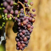
Orchard is also the site of Hexkoel cold storage facility. This massive co-operative cold storage facility is one of the largest of its kind internationally, cooling and dispatching around 16 million cartons of table grapes produced in the area during the grape season between December and April. The Hex River Valley is the oldest and one of the largest table grape production regions in South Africa. Table grapes have been cultivated in the valley and exported for over 100 years and the economy of the area is based almost entirely on the production of table grapes for the export market. The striking autumn colours produced by the vine leaves during May and June with the backdrop of snow covered peaks makes the Hex River Valley a favourite destination for photographers during this season.
Water
There are approximately 5 000 hectares of irrigated land in the Hex River Valley, mostly table grapes. This is under the auspices of the Hex River Valley Water Utilisation Association. Approximately half of the water resources in this region is surface water from dam and river catchment areas and the balance is ground water accessed by boreholes from the area’s abundant aquifers.
The biggest state storage dam in the valley is the Roode Elsberg Dam (also known as Zanddrift dam as it is situated in Zanddrift Kloof). The dam was completed is the source of much of the water available to growers, municipality and industry in the valley. The dam is located in a kloof (narrow valley) which runs more or less parallel to the Hex River to the North. As this valley is separated from the main valley by a mountain range part of this state irrigation project is a 5km long tunnel with a 2 meter diameter that runs through the mountain range and feeds water through gravitation to the pumping station at Orchard. From there it is distributed for agricultural, municipal and industrial purposes.
The Roode Elsberg Dam and water scheme was completed in 1972. The Osplaas dam in the North East of the Valley was completed in 2007.
Text Copyright – Louise Brodie
0781680113
Download the CTA Study Guide 2015 here.